Geography. The topography of the UKThe topography of the UK The total area of the United Kingdom is approximately 243,610 square kilometres (94,060 sq mi). The country occupies the major part of the British Isles[100] archipelago and includes the island of Great Britain, the north-eastern one-sixth of the island of Ireland and some smaller surrounding islands. It lies between the North Atlantic Ocean and the North Sea with the south-east coast coming within 22 miles (35 km) of the coast of northern France, from which it is separated by the English Channel.[101] In 1993 10% of the UK was forested, 46% used for pastures and 25% cultivated for agriculture.[102] The Royal Greenwich Observatory in London is the defining point of the Prime Meridian.[103] The United Kingdom lies between latitudes 49° to 61° N, and longitudes 9° W to 2° E. Northern Ireland shares a 224-mile (360 km) land boundary with the Republic of Ireland.[101] The coastline of Great Britain is 11,073 miles (17,820 km) long.[104] It is connected to continental Europe by the Channel Tunnel, which at 31 miles (50 km) (24 miles (38 km) underwater) is the longest underwater tunnel in the world.[105] England accounts for just over half of the total area of the UK, covering 130,395 square kilometres (50,350 sq mi).[106] Most of the country consists of lowland terrain,[102] with mountainous terrain north-west of the Tees-Exe line; including the Cumbrian Mountains of the Lake District, the Pennines and limestone hills of the Peak District, Exmoor and Dartmoor. The main rivers and estuaries are the Thames, Severn and the Humber. England's highest mountain is Scafell Pike (978 metres (3,209 ft)) in the Lake District. Its principal rivers are the Severn, Thames, Humber, Tees, Tyne, Tweed, Avon, Exe and Mersey.[102] Scotland accounts for just under a third of the total area of the UK, covering 78,772 square kilometres (30,410 sq mi)[107] and including nearly eight hundred islands,[108] predominantly west and north of the mainland; notably the Hebrides, Orkney Islands and Shetland Islands. The topography of Scotland is distinguished by the Highland Boundary Fault – a geological rock fracture – which traverses Scotland from Arran in the west to Stonehaven in the east.[109] The faultline separates two distinctively different regions; namely the Highlands to the north and west and the lowlands to the south and east. The more rugged Highland region contains the majority of Scotland's mountainous land, including Ben Nevis which at 1,343 metres (4,406 ft) is the highest point in the British Isles.[110] Lowland areas – especially the narrow waist of land between the Firth of Clyde and the Firth of Forth known as the Central Belt – are flatter and home to most of the population including Glasgow, Scotland's largest city, and Edinburgh, its capital and political centre.
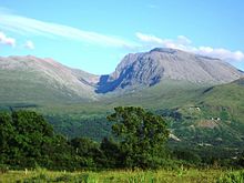
Ben Nevis, in Scotland, is the highest point in the British Isles Wales accounts for less than a tenth of the total area of the UK, covering 20,779 square kilometres (8,020 sq mi).[111] Wales is mostly mountainous, though South Wales is less mountainous than North and mid Wales. The main population and industrial areas are in South Wales, consisting of the coastal cities of Cardiff, Swansea and Newport, and the South Wales Valleys to their north. The highest mountains in Wales are in Snowdonia and include Snowdon (Welsh: Yr Wyddfa) which, at 1,085 metres (3,560 ft), is the highest peak in Wales.[102] The 14, or possibly 15, Welsh mountains over 3,000 feet (914 m) high are known collectively as the Welsh 3000s. Wales has over 746 miles (1,200 kilometres) of coastline. There are several islands off the Welsh mainland, the largest of which is Anglesey (Ynys Môn) in the northwest. Northern Ireland accounts for just 14,160 square kilometres (5,470 sq mi) and is mostly hilly. It includes Lough Neagh which, at 388 square kilometres (150 sq mi), is the largest lake in the British Isles by area.[112] The highest peak in Northern Ireland is Slieve Donard in the Mourne Mountains at 852 metres (2,795 ft).[102]
|