Content and interpreting groups constituting the TAF code
| #
| Coded group
| Content of Group
| |
| CCCC
| Location or place
Four letters ICAO ID‘s designators are used.
| |
| GoGoGHGHgg(Z)
| Date and time of Issue
DD – day
HH – Hour
Mm – Minutes
Z - Time Zone, Z is for Zulu or GMT, UTC.
| | TAF AMD
| TAF Amendment
Designator of Terminal Aerodrome Forecast amendment valid for the period of previous TAF.
| |
| G1G1G2G2gg
| Validity period
| | G1G1
| Day of month at the beginning of validity period.
| | G2G2
| Beginning of forecast period in UTC hours.
| | gg
| End of forecast period in UTC hours.
| |
| dddff(Gfmfm)
| Forecast Surface Wind
| | ddd
| Averaged wind direction is coded in tenth of degrees with three figures.
The direction from which the wind is blowing (meteo) is given with reference to true north.
|
Table 3. Continued
| #
| Coded group
| Content of Group
| |
|
| Directions less than 100 degrees should be preceded by a “0”.
VRB instead of ddd means that expected wind direction varies and averaged wind speed is less than 3 knots (2 mps or 6kmh). In case of strong wind, VRB is used when averaged wind direction is impossible to determine. After VRB the wind speed is reported.
| | ff
| Averaged forecast wind speed is coded in two (three) digits immediately following the wind direction.
If dddff is reported as 00000, it means that no motion of air is expected that is Calm.
The wind group always ends with units of measurement: knots (KT), metres per second (MPS) or kilometres per hour (KMH).
| | Gfmfm
| Forecast wind gusts are coded in two (three) figures just following the wind speed.
fmfm is the maximum instantaneous wind speed. It is reported when maximum wind speed is expected to exceed the “mean speed” by 5 mps (10KT or 20 KPH) during 10 minute interval.
| |
| VVVV
| Minimal Horizontal visibilityon Runway measured in meters.
When Visibility is expected to exceed 10 km it is coded as 9999.
When the horizontal visibility is expected to be not the same in all directions the minimal visibility is given.
| Table 3. Continued
| #
| Coded group
| Content of Group
| |
| W’W’
| Forecast special weather conditions.
Table 1 shows the standards for various elements and descriptors for this group. The definitions of the present weather elements are given in appendix 1.
| | The following special weather phenomena, their descriptions and intensity are included in the TAF:
| -freezing precipitation
-moderate or heavy: Rain, Snow, Ice pellets, Hail, Small hail and/or snow pellets
- Low drifting: Sand, Dust, Snow
- Blowing: Sand, Dust, Snow
- Sandstorm or Duststorm
- Thunderstorm (TSRA, TSSN, TSPE, TSGR, TSGS and their combinations)
- Squall
- Funnel cloud(tornado or Waterspout)
- other weather phenomena that can lead to significant obscuration.
| | NSW
| Is used instead of W’W’ when the end of special weather phenomena is expected.
| |
| NSNSNShShShS(CC) or (VVhShShS)
| Forecast Cloud group
| | NSNSNS
| Forecast Cloud amount, shown by the following abbreviations:
Few is used for 1-2 octas
SCT is used for 3-4 octas
BKN is used for 5-7 octas
OVC is used for 8 octas.
| | hShShS
| Forecast Cloud height. It should be multiplied by 30 to get the value of cloud height in meters and by 100 to get the value of cloud height in feet.
|
Table 3. Continued
| #
| Coded group
| Content of Group
| |
| ///
| Means that Cloud base is lower than the airdrome (in mountain region).
| | CC
| Forecast Type of clouds.Only CB clouds are reported.
| | SKC
| Sky clear.It is reported insteadof cloud group in case of cloud absence.
| | VVhShShS
| Forecast vertical visibility.It is reported insteadof cloud group when the sky is obscured.
VV is the group designator.
hShShS is the Vertical visibility. It should be multiplied by 30 to get the value of cloud height in meters and by 100 to get the value of cloud height in feet.
| |
| VV///
| Vertical visibility not available
| |
| CAVOK
| It is reported insteadof horizontal visibility, RVR, present weather, cloud groups when simultaneous observations are:
Visibility is greater than 10 km,
There are no cloudsbelow 500ft (1500m) or minimum sector altitude, whichever is the lowest and no CB.
There are no significant weather phenomena.
| |
| (T(M)TFTF/GFGFZ)
| Forecast Temperaturesin Celsius.
| | T
| Temperature group designator
| | M
| Designator of negative temperatures
| | TFTF
| Forecast Air Temperature
| | GFGFZ
| UTC Time of Forecast Temperature
| |
| (6IChihihitL)
| Forecast Icing
| |
| Icing group designator.
| | IC
| The type of forecast icing. It is given in coded numbers (table #2).
| Table 3. Continued
| #
| Coded group
| Content of Group
| |
| hihihi
| The lowest level of icing. It should be multiplied by 30 to get the value of the lowest level in metres.
| |
| tL
| Icing layer thickness. It should be multiplied by 300 to get the value of the icing layer thickness in metres.
| |
| (5BhBhBhBtL)
| Forecast Turbulence
| |
| Turbulence group designator.
| | B
| The type of forecast turbulence. It is given in coded numbers (table #2).
| | hBhBhB
| The lowest level of turbulence. It should be multiplied by 30 to get the value of the lowest level in metres.
| | tL
| Turbulence layer thickness. It should be multiplied by 300 to get the value of the turbulence layer thickness in meters.
| | When layer thickness of icing or turbulence is greater than 2700 meters, the groups are repeated. The highest level of phenomena in the preceding group is the lowest level of phenomena in the next group.
| |
| TTTTT GGGeGe and/or TTGG PROBC3C3 GGGeGe
| Change Group and probability of alternating phenomena appearance
| | TTTTT
| Change indicator.One of the following change indicators can be used:
BECMG
TEMPO
PROBC3C3
| | PROB
| Code for probability of forecast.
| | C3C3
| Probability of occurrence in percent (30% or 40%).
|
Table 3. End
| #
| Coded group
| Content of Group
| |
| GGGeGe
| Time group.It indicates the period of changing the phenomena that is indicated in the main body of TAF.
| | GG
| UTC hours from which the change is expected.
| | GeGe
| UTC hours till which the change is expected.
| | TTGG
| It is used when time group forecast is necessary to divide into 2 or more separate groups.
TT is letter indicator that can be:
- FM (from)
- TL (till)
- AT (at).
GG is the UTC hours from when the change is expected.
| |
| TXnn/ttZ
| Forecast max temperature
| | TX
| Indicator for maximum temperature.
| | nn
| Temperature value in Celsius.
| | tt
| Forecast hours when the maximum temperature is expected.
| | Z
| UTC time indicator.
| |
| TNmm/ttZ
| Forecast min temperature
| |
| TN
| Indicator for minimum temperature.
| |
| mm
| Temperature value in Celsius.
| |
| tt
| Forecast hours when the minimum temperature is expected.
| |
| Z
| UTC time indicator.
|
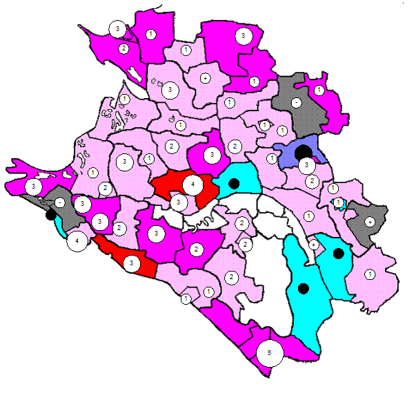
Картограммы и картодиаграммы Картограммы и картодиаграммы применяются для изображения географической характеристики изучаемых явлений...
|
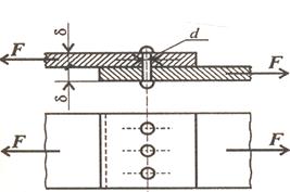
Практические расчеты на срез и смятие При изучении темы обратите внимание на основные расчетные предпосылки и условности расчета...
|
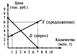
Функция спроса населения на данный товар Функция спроса населения на данный товар: Qd=7-Р. Функция предложения: Qs= -5+2Р,где...
|
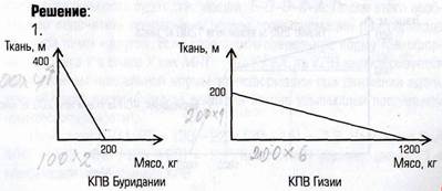
Аальтернативная стоимость. Кривая производственных возможностей В экономике Буридании есть 100 ед. труда с производительностью 4 м ткани или 2 кг мяса...
|
Типология суицида. Феномен суицида (самоубийство или попытка самоубийства) чаще всего связывается с представлением о психологическом кризисе личности...
ОСНОВНЫЕ ТИПЫ МОЗГА ПОЗВОНОЧНЫХ Ихтиопсидный тип мозга характерен для низших позвоночных - рыб и амфибий...
Принципы, критерии и методы оценки и аттестации персонала
Аттестация персонала является одной их важнейших функций управления персоналом...
|
Понятие о синдроме нарушения бронхиальной проходимости и его клинические проявления Синдром нарушения бронхиальной проходимости (бронхообструктивный синдром) – это патологическое состояние...
Опухоли яичников в детском и подростковом возрасте Опухоли яичников занимают первое место в структуре опухолей половой системы у девочек и встречаются в возрасте 10 – 16 лет и в период полового созревания...
Способы тактических действий при проведении специальных операций Специальные операции проводятся с применением следующих основных тактических способов действий: охрана...
|
|
