Content and interpreting groups constituting the METAR code
| #
| Coded group
| Content of Group
| |
| CCCC
| Location or place
Four letter ICAO ID‘s designators are used
| Table 1. Continued
| #
| Coded group
| Content of Group
| |
| GoGoGGgg(Z)
| Date and time of compilation (observation)
DD – day
HH – Hour
Mm – Minutes
Z – Time Zone, Z is for Zulu or GMT, UTC
| | AUTo
| Is used when observation is done by an automatic weather station
| |
| dddff(Gfmfm)
(dndndnVdxdxdx)
| Surface Wind
| | ddd
| Averaged wind direction is coded in tenth of degrees with three figures.
The direction from which the wind is blowing (meteo) is given with reference to true north.
Directions less than 100 degrees should be preceded with a “0”.
The averaging of the direction is made over 2 minute interval.
If it is converted into magnetic degrees, the word magnetic is added.
VRB instead of ddd means that wind direction varies and averaged wind speed is less than 3 knots (2 mps or 6kmh). In case of strong wind, VRB is used when averaged wind direction is impossible to determine. After VRB the wind speed is reported.
| |
| Ff
| Averaged wind speed is coded in two (three) digits immediately following the wind direction.
Averaging period is 2 minutes for take-off and landing airdrome reports.
| Table 1. Continued
| #
| Coded group
| Content of Group
| |
|
| If dddff is reported as 00000, it means that there is no motion of air that is Calm.
The wind group always ends with units of measurements, that are knots (KT), meters per second (MPS) or kilometers per hour (KMH).
| | Gfmfm
| Wind gusts are coded in two (three) figures just following the wind speed.
Fmfm is the maximum instantaneous wind speed over the 10 minute period.
According to WMO standard, it is reported when maximum wind speed exceeds the “mean speed” by 5 mps (10KT or 20 KPH) during the 10 minute interval.
| | DndndnVdxdxdx
| Variation in wind directiongroup is reported if wind direction varies by 60 degrees or more during the 10 minute interval and with averaged wind speed 3 KT (6KPH, 2mps).
The direction variation is coded in a clockwise direction.
V is the group designator.
| |
| VVVVDv
VxVxVxVxDv
| Horizontal visibilitynear the Earthsurface measured in meters.
VVVV is the minimal visibility.
Visibility below 500 m is approximated to the nearest 50 m; Visibility between 500 and 5000 m is approximated to the nearest 100 m; Visibility between 5000 m and 9999 m is approximated to the nearest 1000 m.
Visibility greater than 10 km is coded as 9999.
| Table 1. Continued
| #
| Coded group
| Content of Group
| |
|
| When the horizontal visibility is not the same in all directions (difference is greater than 50 %), it is followed by the direction Dv.
The group VxVxVxVxDv is included in the report when minimal visibility less than 1 500 m and visibility in some other direction exeeds 5000 m.
Codes for Dv are: N for North, NE for Northeast, E for East, SE for Southeast, S for South, SW for Southwest, W for West, NW for Northwest direction.
| |
| RDRDR/(м)(p)
VRVRVRVRi
(RDRDR/VMVMVMVM
VVPVPVPVPi)
| Runway Visual Range.According to ICAO standard RVR is reported in meters when horizontal visibility is less than 1500 metres.
| | R
| Group indicator
| | DRDR/
| Runway number. An additional DR may be used for runway approach directions, such as R for right, L for left, C for centre.
A slash “/” separates the runway number from the constant reportable value.
| | VRVRVRVR
| Visibility in metres.
If RVR is less than its lowest measurable value, the group shall be preceded by M.
If RVR is greater than its highest measurable value, the group shall be preceded by P.
|
Table 1. Continued
| #
| Coded group
| Content of Group
| |
| i
| Tendency for the visibility to change, if during the 10 minute interval preceeding the observation the RVR showed the tendency to increase or decrease. In case of no change, it can be omitted. “U” is used for increasing (upward), “D” is used for decreasing (downward), “N” is for no change.
| | RDRDR/VMVMVMVM
VVPVPVPVPi
| The format for varying RVR.
This group is reported instead of RDRDR/(м)(p) VRVRVRVRi, if the value of RVR during the last 1 minute of 10 minute interval of observation changes by 50 metres or 20 % of the mean visibility.
VMVMVMVM is the lowest (minimal) reportable value and VPVPVPV is the highest (peak) reportable value. “V” separates these lowest and highest RVR values.
| |
| W’W’
| Present weather group.
Table 1 shows the standards for various elements and descriptors for this group. The definitions of present weather elements are given in appendix 1.
Separate groups are used for each type of present weather. Each group should be separated from the other by a space. METAR(SPECI) contains no more than three present weather groups.
The weather group is constructed in the following sequence: intensity, followed by description, followed by weather phenomenon.
|
Table 1. Continued
| #
| Coded group
| Content of Group
| |
| NSNSNShShShS(CC) or (VVhShShS)
| Cloud group
| | NSNSNS
| Cloud amount, shown by the following abbreviations:
Few is used for 1-2 octas
SCT is used for 3-4 octas
BKN is used for 5-7 octas
OVC is used for 8 octas.
| | HShShS
| Cloud height. It should be multiplied by 30 to get the value of cloud height in metres and by 100 to get the value of cloud height in feet.
| | ///
| Means that Cloud base is lower than the airdrome (in mountain region).
| | CC
| Type of clouds.Only CB and TCU clouds are reported.
| | SKC
| Sky clear.It is reported insteadof cloud group in case of cloud absence.
| | VVhShShS
| Vertical visibility.It is reported insteadof cloud group when the sky is obscured.
VV is the group designator.
HShShS is the Vertical visibility. It should be multiplied by 30 to get the value of cloud height in metres and by 100 to get the value of cloud height in feet.
| | VV///
| Vertical visibility not available.
| |
| CAVOK
| It is reported insteadof horizontal visibility, RVR, present weather, cloud groups when simultaneous observations are as follows:
Visibility is greater than 10 km.
There are no cloudsbelow 500ft (1500m) or minimum sector altitude, whichever is the lowest and no CB.
| Table 1. Continued
| #
| Coded group
| Content of Group
| |
|
| There are no significant weather phenomena.
| |
| (M)TT/(M)TdTd
| Temperaturesin Celsius.
| | TT
| Air temperature.
| | TdTd
| Dew point temperature.
| | M
| Designator of negative temperatures.
| |
| QPHPHPHPH
| QNH Pressure.
| | Q
| Group indicator. If letter A is present instead of Q, the pressure value is given in mm of mercury.
| | PHPHPHPH
| Pressure value in the whole ector Pascals, approximate to the lower value.
| | Supplementary Information Groups
| |
| REW’W’
| Recent Significant weather.
Weather is only included as recent weather if the same phenomenon of the same or greater intensity is not reported as present weather and is of operational significance.
| | RE
| Group designator.
| | W’W’
| The appropriate abbreviations contained in table #1 if the following weather phenomena were observed not at the time of the observations:
- freezing precipitation;
- moderate or heavy rain or snow;
- moderate or heavy ice pellets, hail, small hail or snow pellets;
- moderate or heavy blowing snow;
- sandstorm or duststorm;
- thunderstorm;
- volcanic ash.
|
Table 1. End
| #
| Coded group
| Content of Group
| |
| WS TKOF RWYDRDR and/or
WS LDG RWYDRDR
| Wind shear.Supplementary information on the existence of wind shear along the take-off path or approach path between runway level and 500 metres (1600 feet).
DRDR indicates the number of runway.
| |
| TREND
| Trend forecast.It is included when significant change is expected for one or several of the observed elements.
| | TTTTT
| Change indicator.One of the following change indicators can be used:
BECMG
TEMPO
NOSIG
| | TTGGgg
| Changing indicator.
TT is letter indicator that can be:
- FM (from)
- TL (till)
- AT (at).
GGgg is the time group that indicates beginning and end of the change.
GG is for hours, gg is for minutes of UTC.
| |
| RMK
| Remarks Section Group
| |
| XXYCKKBB
| Runway state.
It is includedfrom the 1st of October till the 31st of March
| BECMG (Becoming) is used to describe expected changes to meteorological conditions which reach or pass specified threshold criteria at a regular or irregular rate.
TEMPO (Temporary) is used to describe expected temporary fluctuations to meteorological conditions which reach or pass specified threshold criteria and last for a period of less than one hour in each instance and the aggregate cover less than half of the forecast period during which the fluctuations are expected to occur.
NOSIG (No significant change) is used when none of the elements is expected to change significantly or does not reach or pass specified threshold criteria.
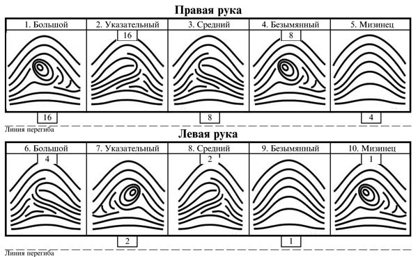
Вычисление основной дактилоскопической формулы Вычислением основной дактоформулы обычно занимается следователь. Для этого все десять пальцев разбиваются на пять пар...
|
Расчетные и графические задания Равновесный объем - это объем, определяемый равенством спроса и предложения...
|

Кардиналистский и ординалистский подходы Кардиналистский (количественный подход) к анализу полезности основан на представлении о возможности измерения различных благ в условных единицах полезности...
|
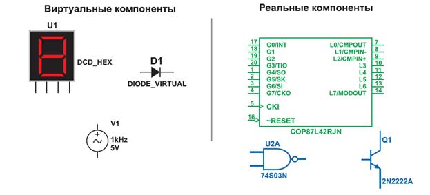
Обзор компонентов Multisim Компоненты – это основа любой схемы, это все элементы, из которых она состоит. Multisim оперирует с двумя категориями...
|
Шрифт зодчего Шрифт зодчего состоит из прописных (заглавных), строчных букв и цифр...
Краткая психологическая характеристика возрастных периодов.Первый критический период развития ребенка — период новорожденности Психоаналитики говорят, что это первая травма, которую переживает ребенок, и она настолько сильна, что вся последующая жизнь проходит под знаком этой травмы...
РЕВМАТИЧЕСКИЕ БОЛЕЗНИ Ревматические болезни(или диффузные болезни соединительно ткани(ДБСТ))— это группа заболеваний, характеризующихся первичным системным поражением соединительной ткани в связи с нарушением иммунного гомеостаза...
|
В теории государства и права выделяют два пути возникновения государства: восточный и западный Восточный путь возникновения государства представляет собой плавный переход, перерастание первобытного общества в государство...
Закон Гука при растяжении и сжатии
Напряжения и деформации при растяжении и сжатии связаны между собой зависимостью, которая называется законом Гука, по имени установившего этот закон английского физика Роберта Гука в 1678 году...
Характерные черты официально-делового стиля Наиболее характерными чертами официально-делового стиля являются:
• лаконичность...
|
|
